Monday, June 09, 2008

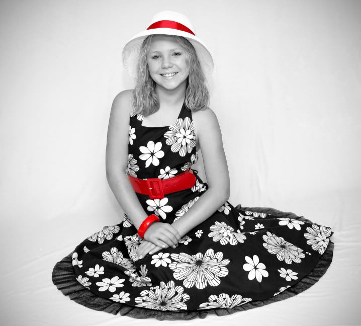
Did a shoot for my wifes sisters daughter. She was excellent to work with. My set up was 1 Canon 580EXII, Canon Rebel XTi, Canon EF 50 1.8


Photobucket

Photobucket

Photobucket

Photobucket

Photobucket

Monday, May 05, 2008

05/01/08 Report:

Pretty ordinary chase. I started out from Iola and decided to go NW into Coffey County. I caught an emerging sup as it began to wall up around LeRoy, KS. At first, it had a pretty decent updraft and I could see scud being drawn into at a rather rapid pace. However, it just couldn't get free of other convection and died a cold rainy death. I then headed south toward Humboldt, KS and some Tor warned storms. I had no live data and made some bad decisions on roads and position and never found myself in an area to see anything else of consequence. I decided to head home around dark.

When I went to sleep around 11:30 I knew a nice line of storms was racing my way. I was awoken at 1 AM by howling winds and trash cans rolling down the street I went to the window and saw some incredible winds. I would estimate at least 60-65.

Decent day with some excitement.

Here area some pics of the wall cloud and sunset below:


Wednesday, April 30, 2008

05/01/08 Severe Weather?

Well it looks like a possible severe weather day tomorrow. It is sort of a strange set up. A split low will throw many wrenches into the set up. Some of the main concerns I have are with low level clouds, lack of SBCAPE, warming 850mb temps and if the moisture can return in time. Some of the things I like are the nicely curved low level hodo, wonderful EHI and 0-3k SRH values of over 300. Will the low occlude? Will there be a forcing mechanism? Will a cap pop up and rear its ugly head? Can we get initiation during the daytime heating or will it initiate after sunset with a stronger LLJ? All things that will be watched closely. We are around 36 hours away from the event and things will look clearer in the morning.

Follow this link to the latest NAM forecast sounding or Chanute, KS.

Later,
Mike

Tuesday, April 29, 2008

Practicing Studio Photography

I set up a mini studio in my living room a couple of weeks ago and took some shots of the girls. I think they turned out better than I expected for sure. The basic set up was a white plush blanket, the back of a couch, a Canon Rebel XTi 400d, a Canon 580EX II and a lot of patience with the girls. For most of the shots I just bounced the flash off the ceiling to get an even light for the shot. There is one of Alli that is a direct flash shot and one of Sarah that is bounced of the wall to camera right. Pretty simple really. I did the post processing with CS2. Most of the PP was using Gaussian blur on the background, adjusting exposure, saturation and levels. I added the vignette and presto. I had the pictures printed at MPIX.com. I HIGHLY RECOMMEND THEM!!!! The shipping was done via regular USPS for $4.95 and I received them the next day. WOW!!! The pictures were exactly as I processed them and cropped perfectly. I well never use Walgreen's or Wal-Mart again. Anyway, without further ado, here are some of the pictures I took. Hope you enjoy.


Saturday, December 22, 2007

Winter Storm Today

Good Morning,

Well, I am well rested and feeling good this morning. Nothing like a good nights sleep to make a person feel better. As far as the weather goes, I am still feeling a little weird about todays possibilities. My main concern is looking at the 850mb RUC charts. As of 8:45 this morning there is a nice batch of precipitation already heading our way. However, it is all rain. Why? Well, at 850mb it is still above freezing. The RUC, in fact, does not even predict that level to cool off until 21z (3PM CST) today. That means if this precip holds together, then for the next 6 hours we will watch it rain. The latest HPC QPF map shows a nice .66" of QPF right over Ottawa. But, will that verify as rain or frozen precip? Only the speed of the low and the shape of the comma head will determine the snow amount here. We will see. I have no doubt we will see nice precip totals around but will it be frozen or liquid? Such is the fun of forecasting.

My official snow predictions 2" in my backyard. We shall see.

Later

Thursday, December 20, 2007

Great Blog

Gary Lezak just put down an excellent blog HERE. I highly recommend you read it.

Frustrating......

This will be a short blog 'cuz I plan on a more detailed blog after the 18z model runs come out.

I am feeling frustrated in trying to forecast winter weather. The models are all over place from run to run. And even when they finally agree on a solution, like last weekend's storm, it busts. I feel for the on air mets and the NWS whose job it is to inform the public on upcoming inclement weather. People really rely on their knowledge and expertise to keep them informed. Hard job for sure.

Give me a severe weather setup any day over a winter weather set up. I feel a hell of a lot more confident predicting severe weather, and more specifically tornado potential, than trying to figure out how much it will snow. WOW, it is tough for me.

More later

Wednesday, December 19, 2007

Phasing Trough

Good Morning,

This morning I am watching a potential strom that will impact me in eastern Kansas sometime Friday night into Saturday. I will discuss in basic terms and with 500mb vorticity charts what the models are predicting.

Picture number 1

Photobucket

As you can see I have circled two pieces of vorticity (energy) that are working their way across the US. For the sake of ease I will call these storm #1 and storm #2. Strom #1 is up in Canada and is predicted to close off and become a full fledged strom while #2 has not closed off and is just beginning to try and wrap up. At this point #2 is called a trough. Now, if #2 were to closed off and look like #1 in the above picture then we would see a substantial snow storm here.

However, look below....

Photobucket

...it does not close off. In fact storm #1 actually sucks in most of the energy that #2 had originally. This is called phasing. #1 actually "ate up" #2. Now if this happens all we will see is a cold front and maybe a passing flurry or two.

If you are a snow lover you are hoping that #2 does not phase with #1. You hope it closes off and becomes its own storm. Could that happen? Yes! Will it happen? Probably not. Our best chance of snow would come from the chance that #2 phases with #1 AFTER it passes us by, not before. We will see if this happens. I predict that it won't and all we see is cold air and clouds from this system.

Later

Tuesday, December 18, 2007

WOW, Lezak lays himself out.....

If you are not a regular reader of the KSHB weather blog you should be. It offers incredible insight into what professional TV meteorologist go through when making forecasts for the public. In his latest blog entry found HERE he totally lays himself out for future criticism. I like the bold move, personally. He is a firm believer in a recurring annual weather pattern that he has named the LRC (Lezak Recurring Cycle). I don't feel like explaining it here but it is a non-proven and highly circumstantial theory of a cycling weather pattern that sets up each year and repeats itself on a specific day cycle until it is replaced by a new cycle at the end of every summer. Gary 100% believes in this theory and I love hearing and reading about it when he describes it. His passion for it comes through and it intrigues me to continue to think and study it.

Now for the reason of this new blog. He and his fellow meteorologist, Jeff Penner, have found a very intriguing similarity with the La Nina year of 1959-1960. The long wave troughs and the basic day cycle of that year are very similar to what he and Jeff believe is happening this year. They are not identical but very close matches. In that year Kansas City had one of the snowiest years ever. Since Gary is a HUGE snow and winter lover he gets excited about the possibility of snow and winter precipitation. His conclusion is that since the winter on 59-60 is so similar to the pattern of this year that he believes there is a possibility of a whole lot of snow for this winter season. Only time will tell but man he really opened himself up. As usual, he left himself some outs like "We will stick to our winter forecast which includes 19 inches of snow, but now that we know the pattern better I am expecting it to go over that total, possilby much higher." If it only snow around 19" then he will still claim a victory but at the same time if it snows much more then he is right as well. Sort of.

The models continue to put a storm on our region on Saturday the 22nd. Every run flip flops a little bit toward snow, no snow, then snow again. We are still WAY out so I will continue to check in on this system as it evolves. Needless to say, if the 00z run of last night verifies we will have a very good chance at a white Christmas.

Later

Saturday, December 15, 2007

BUST

Well, I have seen some crazy busts before but the NWS really had there hands full and missed this one. The Heavy Snow Warning I was under never materialized. I can't really blame them because I was seeing most of the same data they were and not until the later runs of the RUC were coming out did it become apparent that we were going to get dry slotted. I just can't figure out why the models didn't pick up on this earlier. I also can't figure out how we get a dry slot in a storm that really wasn't a storm yet. It was just a trough sliding by our area. I am going to go back and look at some things to see what I missed. We do have the comma head swinging through this morning and we could see some snow accumulations from it. I really don't care what we get from this last gasp of snow. After having modelitis for 16 straight days now I am going on a break to recoup and rest up. My prediction of 6.25" in my backyard is obviously not going to happen. Oh well, you win some you lose some.

Later

Friday, December 14, 2007

OK, the GFS officially SUCKS!!!!! If only it would have given us a nice swath of .75 QPF for all of eastern Kansas. Oh well, we can't win them all. I am aware that the off hour runs can be not as accurate but the last NAM and GFS are quite depressing if you are a snow lover. I am holding out hope and am going to switch form model mode to radar mode form here on out. I will glance at the RUC occasionally but my main source of forecasting will now come form looking out the window. Good luck to us snow lovers and I hope that I wake up to 7+ inches and have to slip and slide my way into work tomorrow. Maybe a thought or two later but I doubt it.

Later
Alright, the southern part of the Topeka CWA is now under a Heavy Snow Warning. Uhhhh, why now? Why not when the models came out this morning? The new runs aren't coming out for a few more hours. What made them change their mind? Maybe it was a shift change and Blair saw something that the morning forecast didn't. Either way, NWS Topeka is calling for up to 6 inches of snow across the southern portion of their CWA (including me in Ottawa). As usual EAX is always last to update. They wait on ICT and TOP to forecast and match their grids to theirs. I say, be like Gary Lezak and make a forecast 2 days in advance and stick with it. Don't wait for the other people to make your forecast for you.

Later.

Echos already appearing

Well, some echos are already filling in around Dodge City as we speak. This is the beginning of the storm for us.


Dodge City has been upgraded from a Heavy Snow Warning to a Winter Storm Warning. If you are a snow lover then you have to like the trends that are going on out west of here. We shall see.
Well, I guess I better update this thing.

We are all waiting on the snow storm tonight. For the last few days the GFS has been the bull of the models with the QPF. Now the NAM, which had a very hard time even seeing this storm a few days ago has blown us up with snowfall amounts.

I have a feeling that with colder temps and the possibility of higher ratios we could see a general 4+ inches for the whole KC area. Since I live in Ottawa, I am going to put my forecast for my backyard at.......6.25 inches. I will take some pictures of the total and post later to see just how close I came. There is no doubt that there is potential for some insane amounts of snow south of KC along the I35 corridor. Some models put more than a foot of the white stuff in Linn co. We shall see and I will begin to keep this blog more updated with my thought from now on.

Mike